- Posts: 2
- Thank you received: 0
Welcome to the LimeSurvey Community Forum
Ask the community, share ideas, and connect with other LimeSurvey users!
location/map: administrative borders instead of lat/lon-coordinates
- sansibar
-
 Topic Author
- Offline
- New Member
-

Less
More
6 years 7 months ago #157984
by sansibar
location/map: administrative borders instead of lat/lon-coordinates was created by sansibar
Hey surveyer,
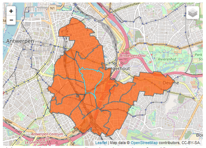
is it possible to display administrative borders/areas on the osm map and let people choose a polygon by highlighting it?
There is that function to display a map and place a symbol on it (category short text answer), the result is geolocation by latitude/longitude. But I would like to show up several polygons and save that one in database, which will be selected by user.
I have a shapefile (could be converted to other formats) with administrative borders.
Photomontage attached for clarity.
Attachments:
The topic has been locked.

- sansibar
-
Topic Author
- Offline
- New Member
-
Less
More
- Posts: 2
- Thank you received: 0
6 years 7 months ago #158190
by sansibar
Replied by sansibar on topic location/map: administrative borders instead of lat/lon-coordinates
What I have done so far:
- converted shapefile with a QGIS plugin to a leaflet JavaScript.
- replaced folder in third_party/leaflet with above content
But map view in survey has not changed although original files of leaflet are replaced. The map itself works when running as dedicated html page.
I don't have a clue, how to make a selection in leaflet permanent and transfer the result to limesurvey database.
Any suggestions?
The topic has been locked.
- mascarpone
-
- Offline
- Premium Member
-

Less
More
- Posts: 129
- Thank you received: 6
6 years 7 months ago - 6 years 7 months ago #158215
by mascarpone
Replied by mascarpone on topic location/map: administrative borders instead of lat/lon-coordinates
Hi Sansibar!
I can unfortunately not help on this, but just to mention it would indeed be very welcomed!
We also collect most of our data against admin units in various countries
Please let me know if you work something out,
Mas
I can unfortunately not help on this, but just to mention it would indeed be very welcomed!
We also collect most of our data against admin units in various countries
Please let me know if you work something out,
Mas
Last edit: 6 years 7 months ago by mascarpone.
The topic has been locked.
- DenisChenu
-

- Offline
- LimeSurvey Community Team
-

Less
More
- Posts: 13643
- Thank you received: 2491
6 years 7 months ago #158224
by DenisChenu
Assistance on LimeSurvey forum and LimeSurvey core development are on my free time.
I'm not a LimeSurvey GmbH member, professional service on demand , plugin development .
I don't answer to private message.
Replied by DenisChenu on topic location/map: administrative borders instead of lat/lon-coordinates
If the map is "restricted" , maybe it's more easy to use a picture with
See demonstration.sondages.pro/21764
And with imagemap : github.com/stowball/jQuery-rwdImageMaps or an example with a multiple choice question type : www.outsharked.com/imagemapster/examples/usa.html
See demonstration.sondages.pro/21764
And with imagemap : github.com/stowball/jQuery-rwdImageMaps or an example with a multiple choice question type : www.outsharked.com/imagemapster/examples/usa.html
Assistance on LimeSurvey forum and LimeSurvey core development are on my free time.
I'm not a LimeSurvey GmbH member, professional service on demand , plugin development .
I don't answer to private message.
The topic has been locked.
- tpartner
-
- Offline
- LimeSurvey Community Team
-
Less
More
- Posts: 10108
- Thank you received: 3593
6 years 7 months ago #158230
by tpartner
Cheers,
Tony Partner
Solutions, code and workarounds presented in these forums are given without any warranty, implied or otherwise.
Replied by tpartner on topic location/map: administrative borders instead of lat/lon-coordinates
Following up on Denis' comment about ImageMapster, here is an online tool to create the image maps (area coordinates) -
imagemap-generator.dariodomi.de/
Cheers,
Tony Partner
Solutions, code and workarounds presented in these forums are given without any warranty, implied or otherwise.
The topic has been locked.
- DenisChenu
-
- Offline
- LimeSurvey Community Team
-
Less
More
- Posts: 13643
- Thank you received: 2491
6 years 7 months ago #158242
by DenisChenu
Assistance on LimeSurvey forum and LimeSurvey core development are on my free time.
I'm not a LimeSurvey GmbH member, professional service on demand , plugin development .
I don't answer to private message.
Replied by DenisChenu on topic location/map: administrative borders instead of lat/lon-coordinates
Or follow :
www.gimp.org/tutorials/Image_Map/
@tpartner : we don't have a workaround for image map in manual ? (if not i must put one ).
For the javascript : i use id on the map, not link.
@tpartner : we don't have a workaround for image map in manual ? (if not i must put one ).
For the javascript : i use id on the map, not link.
Assistance on LimeSurvey forum and LimeSurvey core development are on my free time.
I'm not a LimeSurvey GmbH member, professional service on demand , plugin development .
I don't answer to private message.
The topic has been locked.